
I’ll be honest with you — Hill Canyon Trail doesn’t always get the hype it deserves. You hear people talking about Paradise Falls or Point Mugu, and meanwhile this gem out in the Santa Rosa Valley is just sitting there, quietly being one of the most accessible, beautiful, and genuinely enjoyable hikes in all of Ventura County.
So we packed the camera, and got out there. Here’s everything you need to know…
Hill Canyon Trail is part of the Conejo Canyons Open Space — a 1,628-acre preserved open space managed by the Conejo Open Space Foundation (COSF). Officially dedicated in 2014 (after a forty-year community effort to save this land from neglect and illegal dumping — yes, locals literally fought for this), the trail system winds through Hill Canyon along the Arroyo Conejo Creek.
The canyon itself has deep roots. This land was home to the Chumash people for thousands of years, and there have been archaeological discoveries of Chumash artifacts and pictographs along the creek. That’s not just a trail — that’s living history beneath your feet.
| Detail | Info |
|---|---|
| Distance | 2 miles (easy out-and-back) to 3.6–4 miles (with Hawk Canyon extension) |
| Elevation Gain | ~250 feet — nothing epic, just enough to feel good |
| Difficulty | Easy to Moderate |
| Trail Type | Out and Back (connector options available) |
| Estimated Time | 1 to 4 hours depending on your route |
| Dogs Allowed? | Yes — very dog-friendly (leash required) |
| Stroller Friendly? | Yes, for the first 0.9 miles |
| Bikes & Horses? | Yes — multi-use trail |
| Permit Required? | No |
Getting to Hill Canyon is straightforward, and that’s part of why I love it — no sketchy dirt roads, no confusing unmarked turnoffs.
From the 101 Freeway in Camarillo: Take Exit 52 onto Santa Rosa Road and head northeast. Drive about 5 miles, then turn right onto Hill Canyon Road. Follow it about 0.6 miles — you’ll go over a single-lane bridge — and the parking lot will be on your left.
From Moorpark Road: Head west on Santa Rosa Road for about 3.7 miles, then turn left (south) onto Hill Canyon Road. The lot is 0.6 miles down on the right.
You’ll see a sign for Santa Rosa Regional Park when you turn — that’s your cue that you’re going the right direction.
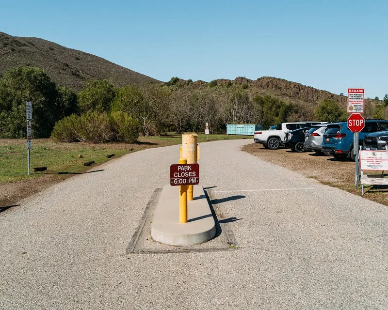
There are two parking areas at Santa Rosa Valley Park. The main lot is a large dirt lot directly across from the iconic Conejo Canyons Bridge — the 145-foot bridge that crosses the Arroyo Conejo Creek and marks your official trailhead. There’s also a gated paved lot to the right of Hill Canyon Road.
Parking is free and relatively easy on weekdays. On weekends, especially in spring when the wildflowers pop, it fills up faster. Pro tip: get here before 9 a.m. on a weekend morning and you’ll have no problem. After 10 a.m.? It gets busy.
Good news here — this isn’t one of those trailheads that leaves you wondering. At the end of the main parking lot, there is a restroom with running water and a water fountain. For a free, public open space trail, that’s a win. There are also picnic tables near the trailhead entrance shaded by oak trees — perfect for a post-hike snack or a pre-hike stretch.
Trail maps of the entire Conejo Canyons Open Space are available at the bulletin board near the trailhead. Grab one. Seriously. The trail system branches off in several directions, and having a paper map means you can explore without worrying about cell signal.
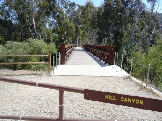
Step one: cross the bridge. The Conejo Canyons Bridge is kind of a moment in itself — especially if you’re filming. It’s a beautiful structure framing the creek below, and on the right day with the right light, it’s genuinely cinematic.
Once across, you’re on the trail proper. The path is wide and well-maintained — mostly a fire road width — and follows Arroyo Conejo Creek on your left side. “Arroyo Conejo” is Spanish for “Rabbit Creek,” and it’s the longest creek in the Conejo Valley, running through Camarillo, Newbury Park, Thousand Oaks, and Santa Rosa Valley before eventually reaching Mugu Lagoon and the Pacific Ocean. That’s kind of wild to think about as you’re just walking along it.
Most of the trail is exposed to the sun, so bring a hat and sunscreen — especially in summer. But there are pockets of shade under the coast live oaks, and a few rest areas with benches where you can sit and just absorb the scene.
The walls of the canyon rise up around you as you walk deeper in. To your left, you’ll catch views of the Mount Clef Ridge with its dramatic volcanic outcroppings. Eroded canyon walls, rugged ridgelines, riparian habitat, and open sage scrub — this place looks like Southern California at its most raw and beautiful.
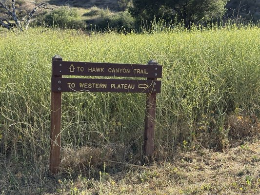
At about 0.9 miles, you hit a junction where the trail splits off in a few different directions. If you’ve got a stroller or little ones who are done, this is a good natural turnaround point. If you want to keep going, you’ve got options.
One of the best things about Hill Canyon is how customizable it is.
Let’s talk scenery, because this trail delivers. Depending on the season and your luck, here’s what you might encounter:
Wildlife: Rabbits, deer, quail, ducks, and even some fairly impressive fish in the creek. In 2013, a protected Steelhead Trout was confirmed in the Arroyo Conejo — a major deal ecologically. Mountain lions, bobcats, and coyotes also live in the canyon, though sightings are rare.
Vegetation: Coast Live Oak woodlands, riparian habitat, coastal sage scrub, chaparral. It’s a rich ecosystem. The diversity of plant life here is genuinely impressive for a Ventura County day hike.
Wildflowers: Come in late winter or spring after a rainy season and you will not be disappointed. The hillsides burst with color, and the creek area especially comes alive with blooms. If you’re filming content — spring is your golden window.
The Creek Itself: There are spots along the trail where you can take narrow side trails down to the Arroyo Conejo. Some swimming holes exist where the creek runs deep enough. Just watch for poison oak on those side paths — it’s definitely there.
This is a wild space. A few things to keep in mind:
Early morning wins every time. Not just because you’ll beat the parking crunch on weekends, but because the light on those volcanic ridgelines in the first hour after sunrise is absolutely stunning — especially for video content. The golden hour here is real, and the trail is quiet enough that you can actually hear the creek.
Spring mornings (February through April) are the absolute peak experience — wildflowers, full creek flow, mild temperatures, and wildlife activity at its highest.
Summer: Go early (before 8 a.m.) or wait until early evening. Most of this trail is exposed, and afternoon summer heat is no joke. The creek provides some relief but not enough to make midday hiking comfortable.
Fall and Winter: Honestly underrated seasons here. The canyon has a moody, atmospheric quality when it’s overcast, and you’ll have the trail almost to yourself on weekday mornings.
Complete beginners who want to try their first real trail in nature
Families with young kids — the flat, wide path and creek views are perfect
Dog owners looking for a substantial walk that isn’t just a sidewalk
Stroller parents for at least the first mile
Content creators and photographers — the scenery is endlessly shootable
Experienced hikers who want to use this as a launching pad for longer routes
Hill Canyon Trail exists because people in this community decided it was worth fighting for. That forty-year effort — from the neglected, graffiti-covered dumping ground it became in the 1970s to the 1,430-acre preserved open space it is today — is a Ventura County success story. Every time you walk this trail, you’re walking on land that locals saved.
That means something….
Next up – Rose Valley Falls in Ojai
Explore more local Ventura County trails, businesses, and community stories at vclocalsonly.com. We’re the network built by locals, for locals — from Fillmore to the coast, and everywhere in between.
Have a trail you want us to cover next? Drop it in the comments or reach out on our socials. One trail at a time — let’s go.
Trailhead Address: Hill Canyon Road off Santa Rosa Road, Camarillo, CA 93012
Trail Management: Conejo Open Space Foundation — conejo-openspace.org
Photo opportunities: Conejo Canyons Bridge, Arroyo Conejo Creek, Mount Clef Ridge volcanic outcroppings, wildflowers (spring), canyon walls